By
By How Luoyang Sites Represent Each Capital Era
Which places should you visit if you want to identify a specific capital era rather than simply see famous monuments? The answer matters because Luoyang was repeatedly used as a political center, but its surviving evidence is spread across archaeological zones, religious sites, reconstructed gateways, museum displays, and later urban districts.
A useful visit does not begin with a general dynasty list. It begins by asking what kind of evidence survives from each period: a city-wall line, palace foundations, a gate, a temple footprint, burial material, or a religious monument created while the city served as a capital. This guide connects major Luoyang places with the capital periods they best represent, while also explaining where the evidence is incomplete.
Which capital eras are most clearly visible on the ground?
The strongest historical matches fall into four broad groups: Eastern Zhou, Han through Northern Wei, Sui and Tang, and the Wu Zhou period. Some locations preserve original archaeological remains. Others use reconstruction or interpretation to explain structures that no longer stand above ground.
| Capital era | Approximate historical period | Best site or zone to visit | What the visitor can actually understand there | Main limitation |
|---|---|---|---|---|
| Eastern Zhou | From the move east in the eighth century BCE to the end of Zhou rule | Eastern Zhou Royal City archaeological area and Wangcheng Park surroundings | The early royal-city landscape associated with Wangcheng and Chengzhou traditions | Most palace and city structures do not survive above ground |
| Eastern Han | First to early third century CE | Han-Wei Luoyang City archaeological site | The location of an imperial capital northeast of the modern urban core | Visitors must rely heavily on site interpretation and maps |
| Cao Wei and Western Jin | Third to early fourth century CE | Han-Wei Luoyang City archaeological site | Continuity of the same capital zone under successive regimes | The site cannot be read as a separate, fully preserved Cao Wei or Jin city |
| Northern Wei | Late fifth to early sixth century CE | Han-Wei city zone, Yongning Temple area, and Longmen Grottoes | A capital-city setting combined with Buddhist patronage | Longmen is not a palace complex or city-center ruin |
| Sui and Tang eastern capital | Early seventh to tenth century CE | Sui-Tang Luoyang City site, Dingding Gate, and palace-city areas | Large-scale urban planning, gateways, roads, and imperial-city geography | Several visible features are reconstructed or presented through excavation evidence |
| Wu Zhou | Late seventh to early eighth century CE | Mingtang and Tiantang area within the Sui-Tang city zone | The ceremonial and political setting of Wu Zetian’s court in the eastern capital | Current buildings should not be mistaken for untouched originals |
Practical conclusion: travelers with one full day should choose one archaeological capital zone and one religious or ceremonial site. This works best for students, history-focused visitors, and researchers who want clear chronological connections. It does not suit visitors looking only for intact ancient buildings, because much of the capital evidence survives below ground.
How do surviving sites and archaeological zones match specific capital periods?
This is the key distinction: Luoyang should be understood through site-to-era matches, not through a broad dynasty timeline. A dynasty may have ruled China without using the city as its primary capital, while one archaeological zone may represent several consecutive regimes.
Eastern Zhou and the royal-city landscape
The Eastern Zhou period is best approached through the Eastern Zhou Royal City area, often associated with the historical locations called Wangcheng and Chengzhou. After the Zhou court moved east, the region became the political center of the Eastern Zhou world. The remains are significant because they point to urban organization, defensive boundaries, and royal occupation long before the later imperial capitals.
Choose this area if your question is, “Where did the eastern Zhou kings rule?” Do not choose it if you expect standing halls, visible palace walls, or a complete ancient streetscape. The value is archaeological and geographical: it establishes where the royal city stood in relation to later development.
Eastern Han, Cao Wei, and Western Jin in one capital-city zone
The Han-Wei Luoyang City archaeological site is the most useful location for understanding the capital from the Eastern Han through Cao Wei and Western Jin periods. The city zone was reused and reshaped over time, which is precisely why it should not be reduced to a single dynasty label.
For the Eastern Han, the site represents the imperial capital established after the restoration of Han rule. For Cao Wei and Western Jin, it demonstrates political continuity at the same strategic location, even as ruling houses changed. A visitor should use a chronological map or site signage to identify which walls, gates, palace sectors, and ritual spaces belong to which phase.
Best use case: select this site when comparing how several governments used the same urban framework. Limit: do not assume every excavated feature can be confidently assigned to one ruler or one year. Archaeological interpretation often identifies phases rather than complete original structures.
Northern Wei and the Buddhist capital
Northern Wei moved its capital to Luoyang in the late fifth century. The Han-Wei city zone remains essential because it preserves the location of the Northern Wei capital. The Yongning Temple area is especially valuable for understanding the religious scale of the city, including the setting of a major Buddhist temple complex.
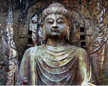
The Longmen Grottoes add another layer. Their Northern Wei sculptures reflect the religious patronage and artistic environment associated with the capital period. They are a strong companion stop, not a substitute for the city site. The grottoes are located along the Yi River and should be read as a sacred landscape connected to the capital, rather than as the capital’s administrative center.
Recommendation: pair the city archaeology with Longmen if you want to understand how court culture, Buddhism, and monumental art interacted. This pairing is less suitable for visitors whose only goal is palace architecture, because neither stop preserves a complete standing palace.
Sui and Tang urban planning
The Sui-Tang Luoyang City archaeological zone represents a different urban scale. The Sui established the eastern capital here, and the Tang continued to use it as an important eastern capital. This area is the best place to study planned avenues, gate systems, palace-city organization, market districts, and the relationship between ceremonial spaces and urban administration.
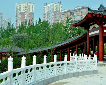
Dingding Gate is particularly useful because it makes the city’s southern approach easier to visualize. A gate visit helps answer a practical question: how did people enter and move through a capital of this scale? The visible interpretation gives spatial clarity, even where original fabric is limited.
Use the Sui-Tang zone when your interest is city planning rather than a single emperor. Do not treat every modern display building as an original monument. Read labels carefully for terms such as “excavated remains,” “site display,” “reconstruction,” and “interpretive restoration.”
Wu Zhou and the Mingtang-Tiantang ceremonial center
During the Wu Zhou period, Wu Zetian made Luoyang her capital and elevated its ceremonial importance. The Mingtang and Tiantang area is the clearest visitor-facing reference point for this era. It helps explain court ritual, imperial legitimacy, and the political use of monumental ceremonial architecture.
The practical value of this stop is interpretive. It connects a named political era to a specific ceremonial district within the Sui-Tang city environment. Its limitation is equally important: present-day structures and displays communicate the historical setting, but they are not simply untouched buildings standing continuously from the Wu Zhou court.
What should travelers avoid when linking a site to a capital era?
The most common mistake is assigning an entire attraction to one dynasty because that dynasty is the easiest label to remember. Historical places in Luoyang often contain multiple layers. Use the following checks before making a connection in notes, coursework, or a guided itinerary.
- Do not equate a religious site with a capital city. Longmen reflects Northern Wei and later patronage, but it is not the location of the imperial palace complex.
- Do not call a reconstruction an original building. A reconstructed gate or hall can explain scale and layout, but it should be described as an interpretation of excavated evidence.
- Do not assign the Han-Wei city zone to Han alone. It also matters for Cao Wei, Western Jin, and Northern Wei history.
- Do not use modern district boundaries as ancient boundaries. Urban growth has changed the relationship between old city sites and modern neighborhoods.
- Do not expect every capital period to have a separate ticketed attraction. Some eras are best understood through layered remains within one archaeological zone.
- Do not overlook site museums and maps. They are often necessary for identifying buried roads, palace sectors, walls, and construction phases.
Conclusion for researchers and students: write the site name first, then state the capital period it represents, then state the type of evidence. For example: “Han-Wei Luoyang City archaeological site — Eastern Han through Northern Wei capital phases — urban and palace-city remains.” This format avoids overstating what can be seen.
How can you build a historically accurate one-day route?
A one-day route should not attempt to cover every era in equal depth. The better approach is to choose a chronological question and arrange stops around it. The following procedure is designed for travelers who want reliable connections between place and period.
- Choose one starting era. Select Eastern Zhou for early royal-city history, Northern Wei for Buddhist capital culture, or Sui-Tang for urban planning and ceremonial government.
- Start at an archaeological capital zone. Visit the Eastern Zhou Royal City area, Han-Wei city site, or Sui-Tang city site before going to religious monuments. This establishes the political geography.
- Record the evidence type. At each stop, note whether you are seeing excavated foundations, a reconstructed structure, a museum interpretation, or a later monument connected to the period.
- Add one related site. For Northern Wei, add Longmen. For Sui-Tang and Wu Zhou, add Dingding Gate or the Mingtang-Tiantang area.
- Compare maps before leaving. Check how the palace, gate, temple, and residential areas related to one another. This is more useful than collecting isolated photographs.
- State one limitation in your final notes. For example, mention that a visible structure is reconstructed or that the original capital buildings survive mainly underground.
A practical Northern Wei route would begin at the Han-Wei Luoyang City area to establish the capital’s location, continue to the Yongning Temple context if accessible through site interpretation, and end at Longmen to examine Buddhist art linked to the same political environment. This route fits visitors interested in the relationship between state power and religion. It does not provide a complete survey of all Northern Wei archaeology, and it should not be rushed if detailed museum study is the goal.
Which site should you choose for each historical question?
| If your question is | Choose this place first | Why it is the strongest match | What to add if time allows |
|---|---|---|---|
| Where was the Eastern Zhou royal center? | Eastern Zhou Royal City area | It connects the city with early eastern Zhou royal geography | Local museum interpretation or mapped archaeological displays |
| How did one capital serve several successive regimes? | Han-Wei Luoyang City site | It represents Eastern Han, Cao Wei, Western Jin, and Northern Wei phases | Longmen for the Northern Wei religious context |
| What did a planned Sui-Tang capital look like? | Sui-Tang Luoyang City site | It shows the urban framework of the eastern capital | Dingding Gate for entry and road alignment |
| Where can Wu Zetian’s capital setting be interpreted? | Mingtang and Tiantang area | It is linked to the ceremonial center of the Wu Zhou period | The wider Sui-Tang city zone |
| Which site best explains Buddhist patronage during the capital era? | Longmen Grottoes | Its Northern Wei material connects art, religion, and court culture | Han-Wei city archaeology for the administrative setting |
The clearest way to understand Luoyang is to connect each stop to a precise capital function: royal center, imperial city, ceremonial district, gate system, or sacred landscape. That approach gives each site a role and prevents a visit from becoming a disconnected list of dynasties.
Plan your itinerary around one capital-era question and use site maps to verify each historical connection.