
Blog
China Luoyang: Ancient vs Modern Districts Compared

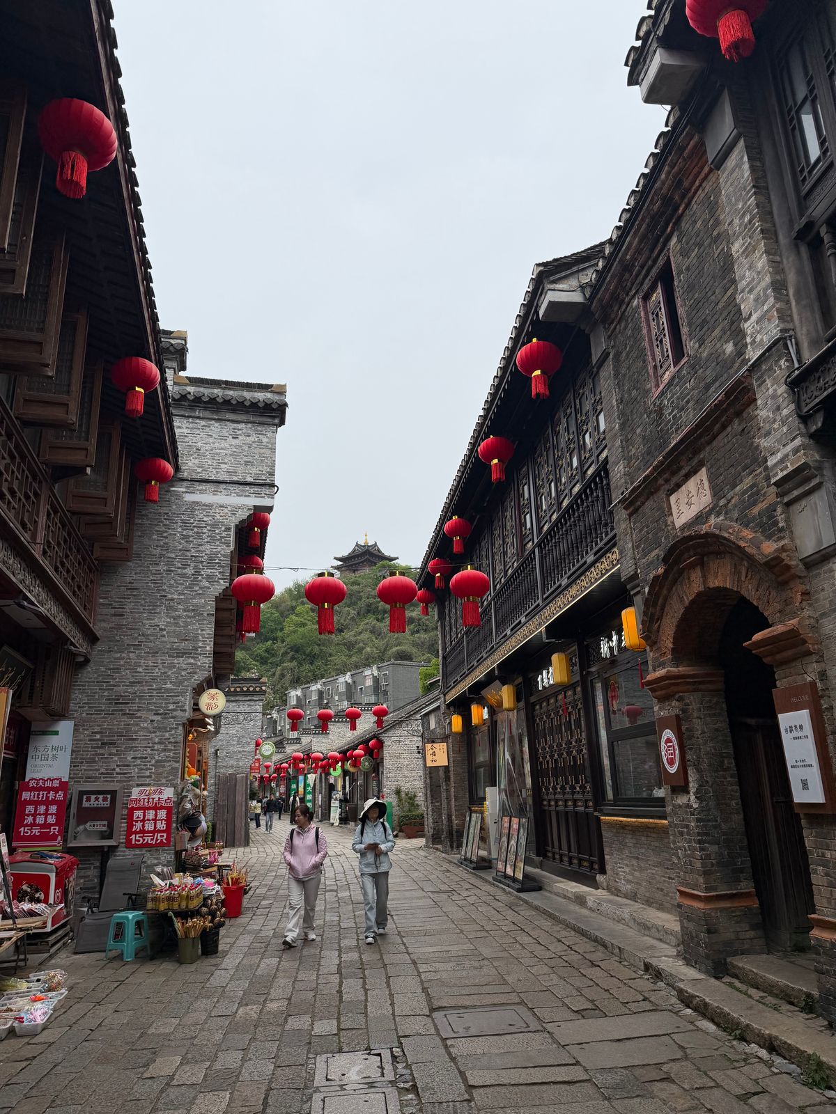
How to Compare China Luoyang’s Ancient and Modern Districts Before You Plan a Visit
If you have already searched a map of Luoyang, you have probably run into the same problem every first-time researcher hits: the city name shows up in three or four different places, and none of the map labels tell you which one holds the temples, tombs, and city walls you actually came for. This confusion is not a map error. Luoyang has been rebuilt and relocated multiple times across its history, and the result is a metropolitan area where old-city remnants, mid-century industrial zones, and brand-new high-rise districts sit side by side. Before you build an itinerary around China Luoyang, you need to understand which parts of the modern city correspond to which historical layer — otherwise you will waste travel days moving between the wrong districts.
This article breaks down the practical differences between Luoyang’s surviving old-city area and its modern urban districts, gives you a checklist for reading local maps correctly, and flags the mistakes most researchers make when they plan site visits from a distance.
Why Luoyang’s Layout Confuses First-Time Planners
Luoyang served as capital during several dynastic periods, and each period built its palace-and-wall complex in a slightly different location along the Luo River basin. Over centuries, flooding, war, and rebuilding shifted the city’s center repeatedly. What this means practically: the “old town” a modern map shows you is usually a Qing-to-Republican-era commercial quarter, not the ancient capital core. The actual imperial-era foundations — palace platforms, city wall traces, archaeological parks — are often several kilometers away, sometimes outside the current urban ring entirely.
For a researcher or traveler, this creates a specific risk: booking a hotel in what map apps label “old town” without checking whether it is near the archaeological sites you actually want, versus a preserved-but-relocated commercial street built for tourism and dining.
Distinguishing the Surviving Old-City Area from Modern Districts on Maps
This is the core skill for planning a Luoyang trip properly. Use the following step-by-step method when you sit down with a digital map before booking anything.
Step-by-Step Map Reading Procedure
- Search the district name in Chinese and English together. Old-city zones are frequently labeled with terms like “Laocheng” (老城, literally “old city”) on Chinese map layers, but English map labels sometimes translate this loosely or omit it. Cross-check both language layers before deciding a location is historic.
- Check the street grid pattern. Surviving old-city areas tend to have narrower, irregular lanes — a layout that predates car traffic. Modern districts show wide, rectangular grid blocks designed for vehicle access. If the map shows uniform city blocks with six-lane arterial roads, you are looking at a post-1980s development zone, not a historic quarter.
- Look for named archaeological parks or heritage-site markers. Ancient capital remains are usually fenced, formally named parks (site museums, city-wall ruin parks, excavation zones), distinct from the commercial “old street” tourist areas. These markers are your best confirmation that you have located genuine historic ground, not a themed reconstruction.
- Cross-reference river and rail lines. Historically, capital cities were sited relative to the Luo River for water access. If a labeled “old district” sits far from the river and instead borders a modern rail corridor or industrial belt, treat that label with caution — it may be a newer district that adopted a historic-sounding name for branding.
- Zoom to street-view level before committing to a hotel booking. Building materials and signage age visibly differ between preserved lanes and rebuilt “ancient style” retail streets. A five-minute street-view check prevents booking into a district that looks historic on a thumbnail but is a modern reconstruction.
Common Failure Reasons at Each Step
- Relying on English-only map labels: Many international map platforms simplify district names, dropping the distinction between “old city” and “ancient capital ruins.” Always verify with a secondary source.
- Assuming tourist-street facades equal historic authenticity: Rebuilt commercial streets are common in Chinese heritage tourism and are legitimate destinations for food and shopping, but they are not the same as archaeological remains — plan your research time separately from your leisure time.
- Ignoring distance between districts: Some researchers assume all “old” and “historic” labeled points are walkable from each other. In Luoyang’s case, different dynastic sites can be a considerable drive apart. Check transit time, not just map proximity.
- Booking accommodation before confirming site locations: This is the most costly mistake. Lock in your priority research sites first, then choose a hotel district based on minimizing daily transit — not the reverse.
Comparing Old-City and Modern District Characteristics
The table below summarizes the practical differences you will notice when comparing the surviving old-city area against Luoyang’s modern urban districts. Use it as a quick-reference checklist while cross-checking your map research.
| Characteristic | Surviving Old-City Area | Modern Urban Districts |
|---|---|---|
| Street layout | Narrow, irregular lanes; pedestrian-scale blocks | Wide grid roads built for vehicle traffic |
| Typical map labels | “Laocheng,” named heritage streets, ruin parks | District numbers, development-zone names, new district titles |
| Building style | Mixed original and reconstructed traditional facades | High-rise residential and commercial towers |
| Primary visitor purpose | Cultural research, walking tours, heritage photography | Business travel, dining, transit hubs, shopping malls |
| Proximity to archaeological sites | Often nearby, but confirm individually per site | Generally farther, may require a taxi or transit connection |
| Transit connections | Older bus routes, fewer subway stops nearby | Newer subway lines and expressway access |
A Practical Scenario: Planning a Two-Site Research Day
Suppose your research goal is to visit one archaeological ruin park in the morning and a preserved old-street commercial quarter in the afternoon for context on how the historic district is presented to visitors today. Here is how to sequence that properly:
- Morning: Confirm the archaeological park’s exact entrance point on the map — many heritage parks have a single official entrance despite spanning a large fenced area. Arrive early since these sites can involve significant walking with limited shade or seating.
- Midday transit: Check whether your accommodation and the ruin park are connected by direct transit or require a transfer. This determines whether a taxi is more time-efficient than public transport for a single research day.
- Afternoon: Shift to the reconstructed old-street district for a contrasting view of how heritage is marketed versus how it is preserved. Treat this as a separate research category — commercial heritage tourism — rather than conflating it with the morning’s archaeological findings.
This sequencing avoids the common mistake of treating the whole day as “the old city,” when in fact you have visited two structurally different types of historic space.
Buyer’s Checklist Before Finalizing Your Itinerary
If you are coordinating a research trip or group itinerary around china luoyang, confirm each of the following before booking transport or accommodation:
- Have you identified which specific dynastic period’s sites are your research priority?
- Have you confirmed each site’s exact map pin using both Chinese and English labels?
- Have you checked street-view imagery to distinguish reconstructed streets from genuine archaeological zones?
- Have you mapped transit time between your target sites, not just straight-line distance?
- Have you chosen accommodation based on proximity to your priority sites, rather than a district’s marketing name?
Researchers commonly consult resources such as UNESCO when cross-referencing which heritage sites in a region carry formal international recognition, since this can help confirm a site’s documented historical boundaries before you finalize a visit plan.
Where This Framework Has Limits
This map-reading method works well for distinguishing broad categories — archaeological zones versus commercial districts versus modern development. It has limits, though. It will not tell you which specific ruin park has the most complete excavation, nor will it substitute for reading site-specific visitor information once available. If your research requires precise archaeological documentation, cross-check with academic or museum publications rather than relying on map interpretation alone. Similarly, seasonal closures or restricted-access areas within heritage parks are not visible on standard maps and require direct confirmation before travel.
Understanding urban district boundaries is also useful context if your itinerary includes stops that blend administrative modern zones with historic cores — a pattern common not just in Luoyang but across many Chinese cities with long capital histories. For travelers cross-referencing multiple cities, a broader heritage city planning guide can help standardize your map-reading approach before you arrive.
If you are building a multi-city research itinerary and want help cross-referencing site locations or transit logistics, reach out to our team for planning guidance or to request a detailed site-location reference sheet.
About LyWOW Tours
LyWOW is a locally based travel agency in Luoyang, specializing in private tours for international travelers across Luoyang, Shaolin, Xi’an and Central China. English-speaking guides, flexible itineraries and door-to-door service.
Learn more about us or browse all our tours.
