By
By Reading Luoyang City Henan Through Its Terrain
Why did one of China’s most enduring imperial capitals rise here, roughly 300 kilometers inland from the coast? The answer sits in the ground itself. Luoyang city Henan occupies a specific geological and hydrological niche that made it defensible, farmable, and connected — three assets that mattered more than almost anything else in pre-industrial statecraft. Before you walk the Longmen Grottoes or trace the old city walls, understanding the terrain gives you a filter for everything you will see.

The city does not sprawl across an open plain. It sits inside a structural basin, hemmed by uplands on several sides. That simple fact explains settlement patterns, military history, and even the orientation of its most famous monuments. This guide breaks down the physical geography of Luoyang city Henan into the features that actually shaped human decisions.
How the Basin, Surrounding Mountains, and Transport Corridors Explain the City’s Historic Settlement Pattern
Settlement did not happen here by accident. Three geographic factors interacted to make Luoyang a rational choice for rulers across multiple dynasties. Each factor solved a specific problem.
The Defensive Logic of a Closed Basin
The Luoyang basin is ringed by mountains. To the north, the Mangshan hills form a low but continuous barrier before the Yellow River. To the west and south, the Xiao Mountains and the Funiu range rise more sharply. To the east, the land opens toward the North China Plain — the one direction a defender had to watch closely.
This created a natural fortress. An army could hold the mountain passes and control access to the entire basin. Food could be grown inside the protected zone. A court could survive a siege longer here than on an open plain. That is why the Eastern Zhou, Eastern Han, and Northern Wei dynasties all placed their capitals in or near this basin, despite periodic flooding risk from the Luo and Yi rivers.
What buyers of historical narratives often miss: the mountains did not just protect. They constrained. The basin is finite. When a dynasty grew too large, the capital had to expand outward, which weakened the defensive advantage. This tension between protection and growth explains why power sometimes shifted to Chang’an (Xi’an) or Kaifeng.
River Access Without Coastal Exposure
The Luo River runs through the heart of Luoyang city Henan, joining the Yi River before flowing into the Yellow River. For ancient logistics, this was close to ideal. Grain, timber, and stone could move by water. The Yellow River connected the basin to the wider North China Plain and, via canals, to the Yangtze system.
But the city sat far enough upstream to avoid the worst of the Yellow River’s catastrophic floods. Coastal cities faced invasion from the sea; Luoyang faced no such threat. The rivers gave connectivity without vulnerability. That balance is rare in Chinese historical geography.
East-West Corridor Between Two Great Plains
Luoyang city Henan anchors the eastern end of the Wei River–Yellow River corridor. To the west, the route climbs through the Hangu Pass toward Xi’an. To the east, it opens onto the flat, productive North China Plain. This made Luoyang the hinge between two economic zones.
When the western Guanzhong region was strong, Luoyang served as its eastern gate. When the eastern plain dominated, Luoyang became the forward capital. The city was rarely the sole center of power for long, but it was almost always the fulcrum. Armies, tax grain, and imperial orders all had to pass through this corridor.
| Geographic Feature | What It Affected | Practical Consequence |
|---|---|---|
| Mangshan hills (north) | Flood control, defense | Contained Yellow River flooding; blocked northern cavalry |
| Xiao Mountains (west) | Pass defense, trade route | Hangu Pass controlled access to Xi’an |
| Luo and Yi rivers | Irrigation, transport | Supported dense urban population; moved heavy stone for monuments |
| Eastern opening | Military vulnerability | Required walls and garrison on the eastern approach |
| Basin floor | Agriculture, urban form | Allowed compact, defensible city plan instead of linear sprawl |
Reading the Terrain Today: What Travelers and Researchers Should Look For
You do not need a geology degree to read the landscape. A few observable features will anchor your understanding.
The Mangshan Hills Are Not Dramatic — That Is the Point
North of the city, the Mangshan hills rise only 100 to 200 meters above the basin floor. They look modest. But their role was enormous. They deflected the Yellow River’s historical course changes, which were frequent and violent. The river once flowed closer to the city than it does today. The hills acted as a levee that humans did not have to build.
When you stand on the Mangshan ridge and look south, you see the entire basin spread out. That vantage point explains why rulers built observation posts and tombs there. The Eastern Han emperors chose the Mangshan slopes for their mausoleums. The location offered visibility over the capital and dry, stable soil for underground chambers.
The Longmen Grottoes Are a River-Cut Corridor
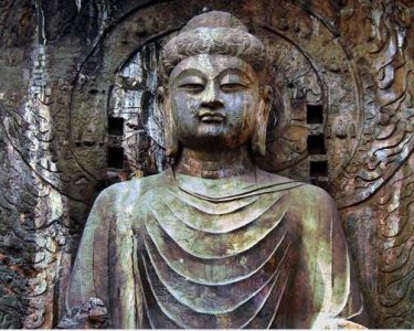
The Longmen Grottoes sit about 12 kilometers south of the old city center, where the Yi River cuts through the Longmen and Xiangshan hills. This is not a random artistic site. The river carved a narrow gorge through resistant limestone, creating vertical cliff faces ideal for carving.
The gorge also functioned as a south gate. Travelers entering Luoyang city Henan from the south had to pass through this gap. The Northern Wei rulers placed Buddhist carvings here deliberately — to sanctify the entrance, to display imperial patronage, and to impress every arrival. The terrain chose the site; the artists exploited it.
The Old City’s Eastern Wall Faced the Only Open Side
Walk the surviving sections of the old city walls, and you will notice the eastern fortifications were historically the thickest and most heavily garrisoned. This is not a coincidence. The east was the only direction without a mountain barrier. Every invader from the North China Plain came from that side.
For researchers, this is a useful rule of thumb: in basin cities, wall thickness and gate design reveal the direction of greatest threat. In Luoyang, the evidence points east.
Common Mistakes When Interpreting Luoyang’s Geography
Visitors and even some published guides make predictable errors. Here are the most frequent ones and how to avoid them.
- Mistake: Treating Luoyang as a river city like Wuhan or Nanjing.
Luoyang is not defined by one great river. It is defined by a basin with multiple small rivers. The Luo River is significant, but it is not the Yangtze. Expecting a grand waterfront will lead to confusion. - Mistake: Assuming the mountains are impassable.
The surrounding ranges are high enough to defend but not to isolate. Passes through the Xiao Mountains were heavily used. Trade and armies moved through them constantly. The mountains slowed movement; they did not stop it. - Mistake: Ignoring the Yellow River’s changing course.
The Yellow River has shifted dramatically over centuries. Modern maps show it north of the Mangshan hills, but historical channels sometimes ran closer. When reading old texts, do not assume the river’s position matched today’s. - Mistake: Expecting all historical sites to cluster in one small area.
The basin is large. The Erlitou site, the Eastern Han capital, the Sui-Tang capital, and the modern city all occupy different positions within the basin. The capital moved several times. A single “old city” does not exist. - Mistake: Viewing the terrain as static.
Erosion, river siltation, and human terracing have altered the landscape. The basin floor today is higher than it was 2,000 years ago because of accumulated silt. Ancient ground levels sit meters below the modern surface.
A Step-by-Step Geographic Reading for Your First Visit
If you have one day to orient yourself before diving into museums and monuments, follow this sequence.
- Start at the Mangshan ridge in the morning.
Look south across the basin. Identify the Luo River, the modern city, and the distant southern hills. This gives you the full frame. - Drive or walk south along the Luo River corridor.
Notice how the valley narrows as you approach the Longmen hills. The river has cut through the ridge, and the cliffs rise on both sides. - Stop at the Longmen Grottoes entrance.
Before looking at the carvings, look at the gorge itself. Note the cliff height, the river width, and the narrow passage. This was a controlled entry point. - Return north and trace the eastern edge of the old city.
Compare the eastern wall remains with the western side. The difference in fortification tells you where the threat came from. - End at the Sui-Tang Luoyang City National Heritage Park.
Here, the grid layout of a planned imperial capital shows how the basin floor was organized. The flat land allowed a regular, rectangular plan — something impossible in a mountainous site like Chongqing.
This sequence takes most of a day and gives you the geographic literacy to interpret everything else you see.
What the Terrain Explains That Guidebooks Often Skip
Three deeper patterns emerge once you understand the physical setting.
First, the repeated return of capital status. Luoyang city Henan was not continuously a capital. It rose and fell. But whenever China was divided or the eastern plain needed a forward base, rulers returned. The terrain did not change. The strategic logic did not change. The basin remained the same asset across 3,000 years.
Second, the location of imperial tombs. The Mangshan hills north of the city hold one of the densest concentrations of ancient tombs in China. Dry loess soil, elevation above the floodplain, and a view over the capital made this the preferred burial ground. The terrain dictated funerary geography as much as political geography.
Third, the limits of the basin. Luoyang’s basin is smaller than the Guanzhong plain around Xi’an. It could support a large city but not an enormous one. When imperial ambitions outgrew local agriculture, the court had to import grain at high cost. This recurring constraint pushed some dynasties to move the capital to more productive regions. The terrain set a ceiling on growth.
For cultural researchers, these patterns are entry points. A geographic question — “why here and not there?” — often unlocks more than a chronological list of dynasties.
Practical Notes for Reading the Landscape in Person
Weather and season change how the terrain reads. In winter, the hills are bare and the basin’s structure is most visible. In summer, dense vegetation obscures the mountain outlines but makes the river corridors clearer. Early morning haze often fills the basin, showing its enclosed shape from above — a useful visual if you can reach a high point before sunrise.
Public transportation reaches the main sites, but the Mangshan ridge and the Longmen gorge are best accessed by private car or taxi if you want to stop and observe. The distances are not long, but the viewpoints are not always on standard bus routes.
If you are researching remotely, start with topographic maps rather than political maps. A 1:250,000 or 1:100,000 topographic sheet will show the basin rim, the river courses, and the pass locations far more clearly than any standard tourist map. Cross-reference with historical atlases that show the Yellow River’s shifting channels over time.
One final caution: do not compress Luoyang’s geography into a single mental image. The basin is not a bowl with one rim. It is an irregular depression with multiple sub-valleys, terraces, and micro-regions. The Erlitou site sits on a different terrace than the Eastern Han capital. The Sui-Tang city occupied yet another alignment. Read each site’s specific micro-terrain, not just the regional frame.
If you are planning field research or a structured cultural itinerary through Luoyang city Henan, and you want geographic context matched to specific sites, send us your route and research focus. We can point you to the terrain features that matter for your questions — and the ones you can safely skip.