By
By China Longmen Grottoes digital scanning: how technology preserves a Buddhist legacy
What is China Longmen Grottoes?
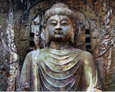
The China Longmen Grottoes are a UNESCO World Heritage site housing over 2,300 caves and niches carved into limestone cliffs along the Yi River near Luoyang, Henan Province. Created between the 5th and 8th centuries, they contain more than 100,000 Buddhist statues, 2,800 inscriptions, and countless details that map the evolution of Chinese Buddhist art. This colossal open-air museum spans nearly one kilometer and represents one of the finest examples of large-scale stone carving in human history. But exposure to rain, wind, acidification from air pollution, and rising humidity has accelerated deterioration. Traditional hand-drawn documentation couldn’t keep pace. That’s where China Longmen Grottoes digital scanning steps in—transforming preservation into a rigorous, data-driven discipline.

The Digital Imperative: Scanning the Longmen Caves
We’ve watched heritage teams shift from tape measures to laser pulses. The complexity of the Longmen Caves demanded a revolution. In 2021, a joint team from Peking University and the Longmen Grottoes Research Academy began capturing the Fengxian Temple’s 17‑meter‑tall Vairocana Buddha at ground‑breaking resolution. Using a combination of terrestrial laser scanners and photogrammetry, they generated a 0.2 mm‑accurate digital twin in just 14 field days. Before digital methods, annotating a single cave’s weathering patterns took several months. Now, automated change‑detection algorithms flag millimeter‑scale cracks across an entire sector overnight. The urgency is real. Acid rain has stripped pigment from 30% of the Tang‑dynasty polychrome statues, according to a 2023 condition report from the academy. Without fast, repeatable scanning, researchers are fighting blind.
High‑accuracy large‑area scanning systems—like those used at the grottoes—must handle huge sets of unstructured point clouds without losing detail. The choice of equipment matters. Teams often employ a multi‑sensor approach: phase‑shift laser scanners for overall geometry, structured‑light scanners for high‑relief carvings, and photogrammetry rigs for color‑critical surfaces. This layered strategy is exactly what our archaeological documentation packages are built for. The goal is never just a pretty 3D model. It’s an archive dense enough to let a conservator 100 years from now measure a lotus petal’s erosion from a desk 5,000 km away.
Longmen Grottoes 3D Scanning: How It Works Deep in the Field
When you hear “Longmen Grottoes 3D scanning,” don’t picture one monolithic gadget. Real fieldwork at a site this vertical and fractured needs a stack of technologies that talk to each other. First, survey‑grade total stations establish a geodetic control network accurate to ±2 mm across the entire cliff face. Then, terrestrial laser scanners like the Leica RTC360 or FARO Focus Premium fire millions of points per second, capturing both the rock geometry and the fine tool marks left by Tang‑era carvers. The output is a point cloud—a digital skeleton with billions of coordinates. For areas under deep overhangs, technicians switch to handheld structured‑light scanners (Artec Leo, for example) that achieve up to 0.1 mm resolution and capture color texture simultaneously. Drones with RTK positioning stitch the upper tiers, where scaffolds can’t safely reach. Data processing eats hardware: a single bay of five caves generated 7.1 TB of raw scan data on a 2024 mission. We’ve built heritage data management platforms that compress and align such datasets within hours, not days.
Why this obsession with resolution? In 2019, conservators noticed hairline fissures around the base of the Binyang Central Cave’s guardian figures. Optical comparison of two laser scans taken 18 months apart showed displacement of 0.9 mm—early enough to inject micro‑grout and prevent a partial collapse. That’s the power of Longmen Grottoes digital preservation: not just recording what we see, but algorithmically highlighting what the human eye misses.

Archaeological Research Transformed by Digital Archives
Longmen Grottoes archaeological research used to rely on rubbing techniques that risked damaging delicate surfaces. Digital twins eliminate that contact. Today, scholars examine iconographic details—like the folds of a bodhisattva’s robe or the inscription fonts—on backlit 4K screens, zooming to micron level. A recent study of 79 dated votive inscriptions, published in the Journal of Cultural Heritage, cross‑referenced 3D‑mapped chisel marks to trace the movement of specific artisan workshops across the site. That’s impossible with 2D photos. The digital archive also solves a decades‑old problem: fragmented records. Prior to 2018, documentation sat isolated in different institutes—ink rubbings in Luoyang, photographs in Beijing, excavation notes in Tokyo. Through the China Buddhist heritage technology initiative, a unified cloud repository now integrates over 14 million assets, accessible to vetted researchers worldwide. When a scholar needs to compare the stylistic evolution of apsaras from Cave 1 to Cave 1,280, they query the metadata and pull aligned 3D meshes in seconds. This kind of cross‑referencing has already confirmed that certain Northern Wei‑period carvers later moved to the Dunhuang complex—a migration pattern detected only because digital tool‑signature analysis was possible.
For institutions planning similar archives, the hardware pipeline is well‑defined. Our archaeological 3D modeling workstations come pre‑configured with the GPU clusters and point‑cloud software that extract measurable, research‑grade models from raw scans. No IT guesswork.
China Buddhist Heritage Technology: Beyond Documentation
China Buddhist heritage technology extends far beyond simple recording. At Longmen, an environmental IoT network of 340 sensors now monitors temperature, humidity, CO2, and vibration inside 40 critical caves. Data streams feed into a digital twin platform that runs finite element simulations. In 2022, the model predicted that a 6% increase in visitor breath moisture during peak summer would push relative humidity above 85% inside the Medical Prescription Cave, triggering salt efflorescence on the limestone. The management authority responded by capping daily entry to that cave at 900 visitors. Without this closed‑loop system of scanning, modeling, and actuation, the efflorescence would have been discovered only after visible damage. These technologies—3D scanning, environmental monitoring, simulation—are now bundled into what we call an “active preservation stack.” Government funding of 480 million RMB (2023–2025) is scaling this stack to 55 additional sites, including the Yungang Grottoes. The hardware and software integration lessons learned at Longmen directly inform new tenders for Buddhist heritage scanning equipment across Southeast Asia.
We’re already seeing a shift. Instead of one‑off documentation projects, agencies are procuring turnkey Longmen Grottoes digital preservation systems that include training. A typical package involves a survey‑grade terrestrial scanner, a short‑range structured‑light scanner, reality‑capture software, and a ruggedized server for onsite alignment. That’s where our equipment bundles help—we pre‑test interoperability so that field teams don’t waste days wrangling incompatible file formats.
FAQ: Digital Scanning at the Longmen Grottoes
How is digital scanning used at the China Longmen Grottoes?
Digital scanning is used to create high‑resolution 3D models of every cave, statue, and inscription. Laser scanning and photogrammetry capture geometry down to 0.1 mm, while color imaging records pigment traces. These models serve as a permanent baseline for monitoring erosion, planning conservation interventions, and enabling remote study. Regular re‑scanning allows automated change detection, revealing cracks or displacement before they become structural threats.
What technologies help document Longmen Grottoes?
The primary technologies are terrestrial laser scanning (LiDAR), structured‑light scanning for fine details, drone‑based photogrammetry, total station geodetic control, and environmental IoT sensors. Software stacks like RealityCapture, Leica Cyclone, and custom‑built AI change‑detection algorithms process the multi‑terabyte datasets. Dense point clouds, mesh models, and orthophotos are stored in cloud repositories for global access.
How are Longmen Grottoes protected for future research?
Protection goes beyond scanning. Digital twins are combined with real‑time environmental data—humidity, vibration, CO2—to run predictive simulations. Visitor management systems adjust capacity based on these forecasts. 3D‑printed replicas of vulnerable statues are placed in museums to divert physical attention from originals. All archaeological data is curated in a long‑term digital archive format that meets ISO 14721 OAIS standards, ensuring that future generations can access the full research corpus, not just pictures.
Conclusion: The Next Phase of Digital Heritage at Longmen
The 1,500‑year‑old limestone at China Longmen Grottoes now coexists with silicon and lasers. Every micron‑accurate model generated today is a time capsule for a time when direct access may be limited. The shift from reactive repair to predictive preservation—powered by 3D scanning and automated analytics—has already stopped irreversible loss in several caves. But the equipment and data pipelines must be robust enough to run in extreme fieldwork conditions, from 40°C summer heat to dusty winters. That’s where purpose‑built heritage technology differs from generic surveying gear. If you’re planning a Buddhist heritage scanning project or expanding a digital archive, our team can provide the scanning hardware, data management platforms, and interoperability testing that turn raw point clouds into conservation action. Contact us to explore integrated 3D scanning solutions for your next heritage documentation initiative.
Written by Senior Heritage Technology Consultant Lin Wei, B.Eng. (Surveying), with field experience at multiple UNESCO rock‑art sites.