
Blog
Which Dynasty Built Which Capital Site in Lo Yang China

Which Lo-Yang Dynasty Built Which Capital Site?
Most maps of lo yang china show one dot. That is misleading. The city moved several times. A ruler in 200 CE did not govern from the same physical ground as a ruler in 700 CE. The difference matters for anyone studying urban planning, archaeology, or historical geography. The question is not simply “which dynasty used Lo-Yang.” The real question is which specific walled enclosure, which river terrace, which grid of streets a given house or court actually occupied.
Three major capital sites sit within the modern Luoyang municipal area. Each belongs to a distinct phase of Chinese administrative history. Knowing which dynasty built which site clears up a lot of confusion in older reference books, which often use “Lo-Yang” as a catch-all label.
A Dynasty-to-Capital-Site Mapping for Lo Yang China
This section separates rulers who used an existing Lo-Yang capital from those who expanded it, rebuilt it on a new axis, or shifted the urban center to a fresh location. The distinction is practical. If you are reading a memorial about a palace gate, you need to know which walled city the writer meant.
| Dynasty / Ruler | Capital Site Used | Action Taken | Modern Reference Point |
|---|---|---|---|
| Eastern Zhou (c. 770–256 BCE) | Wangcheng | Used an existing Zhou royal settlement | Area near modern Wangcheng Park, west of the Jian River |
| Eastern Han (25–220 CE) | Han-Wei Luoyang City | Built a new imperial capital on a fresh site east of the old Zhou center | About 15 km east of modern Luoyang, near Baima Temple |
| Cao Wei and Western Jin (220–316 CE) | Han-Wei Luoyang City | Rebuilt and reused the Eastern Han enclosure | Same site as Eastern Han |
| Northern Wei (493–534 CE) | Han-Wei Luoyang City | Expanded the existing city significantly, adding an outer wall and new wards | Same core site, enlarged footprint |
| Sui (605–618 CE) | Sui-Tang Luoyang City | Built a completely new capital on a different site, west of the old Han-Wei city | Overlaps the modern Luoyang old town and Xigong district |
| Tang (618–907 CE, with interruptions) | Sui-Tang Luoyang City | Used and modified the Sui capital, especially under Empress Wu Zetian | Same site as Sui |
| Later Liang, Later Tang, Later Jin (10th century) | Sui-Tang Luoyang City | Reused the Tang enclosure for short-lived administrations | Same site as Sui-Tang |
The key split is between the Han-Wei city and the Sui-Tang city. They are not adjacent. They are roughly 10–15 km apart. A visitor who assumes one continuous “ancient Luoyang” will misread nearly every source written after 600 CE.
Rulers Who Used an Existing Lo-Yang Without Major Rebuilding
The Eastern Zhou kings are the clearest example. They occupied Wangcheng, a walled settlement already tied to Zhou ritual authority. They did not create a new urban plan. They inherited one. The Later Liang, Later Tang, and Later Jin courts of the tenth century did something similar. They moved into the Sui-Tang city and governed from its existing palaces. They repaired roofs and gates. They did not redraw the street grid.
This matters for dating. If a source from the tenth century mentions a palace hall, that hall was almost certainly a Tang structure still in use. The dynasty label alone does not tell you who built the building.
Rulers Who Expanded or Rebuilt on the Same Site
The Northern Wei emperors are the most important case here. They moved their court from Pingcheng to Lo-Yang in 493 CE. They chose the Han-Wei city site, not a blank field. But they did not simply move into the old Jin-era ruins. They laid out a much larger outer city, added a grid of wards, and built new Buddhist temples and aristocratic residences. The core imperial quarter stayed roughly in place, but the urban area around it grew dramatically.
The Cao Wei and Western Jin courts also rebuilt, but on a smaller scale. They restored the Eastern Han enclosure after the destruction of the late second and early third centuries. They reused the same palace axis. The footprint stayed similar. The Northern Wei expansion is the one that changed the city’s physical scale.
Rulers Who Shifted the Urban Center to a New Site
The Sui dynasty made the cleanest break. In 605 CE, Emperor Yang ordered a new capital built. He did not rebuild the Han-Wei city. He chose a new location to the west, where the Luo River and the Jian River meet. The new city had a different orientation, a different palace position, and a different relationship to the river system. The Tang court, including Empress Wu Zetian’s reign, continued to use and modify this Sui-Tang city. The urban center never returned to the Han-Wei site.
This shift is the single most useful fact for anyone reading Tang poetry or administrative documents. When a Tang official writes about “the eastern capital,” they mean the Sui-Tang city. They do not mean the Han-Wei ruins, which by then were a source of building stone and farmland.
How to Identify Which Capital Site a Source Describes
You can often pin down the site without a map. Look for three clues in the text: the river mentioned, the gate name, and the distance to a known landmark.
- River references. The Han-Wei city sat north of the Luo River, with the river running along its southern edge. The Sui-Tang city straddled the Luo River, with the imperial palace on the north bank and many wards on the south bank. If a source says the river ran through the city, it is almost certainly the Sui-Tang site.
- Gate names. The Sui-Tang city had a famous southern gate called Dingding Gate. The Han-Wei city’s gates had different names, many tied to the Zhou-era directional system. A named gate often identifies the city immediately.
- Distance to Baima Temple. Baima Temple sits just outside the Han-Wei city’s eastern edge. A source that places the court “near Baima Temple” points to the Han-Wei site. A source that places it “west of the Jian River” points to Wangcheng or the Sui-Tang city.
This is a practical research habit. It costs a few minutes per source and prevents major errors in site interpretation.
Common Mistakes When Matching Dynasties to Lo Yang China Sites
Several errors repeat across introductory articles and even some academic summaries. Here are the most frequent ones.
| Mistake | Why It Happens | Correct View |
|---|---|---|
| Treating “Luoyang” as one continuous city | Modern maps show a single urban area | At least three distinct capital sites existed, kilometers apart |
| Assuming the Tang used the Han capital | Both are called “Luoyang” in English sources | The Tang used the Sui-Tang city, not the Han-Wei city |
| Placing the Eastern Zhou capital inside the modern old town | The modern old town overlaps the Sui-Tang city | The Zhou Wangcheng lies further west, near the Jian River |
| Crediting the Northern Wei with building the Han-Wei city | Northern Wei sources describe extensive construction | The Eastern Han built the original city; Northern Wei expanded it |
| Using one gate name for all periods | Gate names repeat across dynasties | Gate names are period-specific and site-specific |
The root cause of most mistakes is the label “Luoyang.” Chinese administrative geography uses the same name for a county, a prefecture, and a city across two thousand years. The physical capital moved within that administrative frame. The name did not.
A Step-by-Step Method for Placing a Historical Event in Lo Yang China
Here is a repeatable procedure for anyone working with a primary source, a museum label, or a secondary article.
- Note the date. Determine the dynasty and, if possible, the reign period. This narrows the likely capital site immediately.
- Check the river description. Does the Luo River run south of the city or through it? This alone separates the Han-Wei site from the Sui-Tang site in most cases.
- Look for gate or ward names. A named gate or ward often belongs to a specific city plan.
- Find a fixed landmark. Baima Temple, the Jian River, the Mangshan hills to the north, and the Yi River to the south are stable reference points.
- Match the site to the dynasty. Use the mapping table above. If the source is Tang, start with the Sui-Tang city. If it is Eastern Han or Northern Wei, start with the Han-Wei city. If it is Eastern Zhou, start with Wangcheng.
- Note any rebuilding evidence. If the source says “newly built” or “restored,” check whether the ruler expanded an existing site or created a new one.
This method works for most textual and archaeological questions. It does not solve every ambiguity. Some periods, especially the late Northern Wei and the Sui transition, have incomplete archaeological publication. But it prevents the most common category errors.
What the Archaeology Shows on the Ground
The three sites have different surface visibility today. This affects what a visitor or researcher can actually verify.
Wangcheng. The Eastern Zhou city is largely buried under modern development. The visible reference is Wangcheng Park, which preserves part of the general area. Little of the original wall remains above ground. Most knowledge comes from excavation reports and borehole surveys. A visitor sees a park, not a city wall.
Han-Wei Luoyang City. This site is the best preserved. The eastern, northern, and western wall lines are still traceable in places. The palace area has been excavated. The Yongning Temple pagoda foundation, a Northern Wei structure, is a key visible point. The site is open to researchers and, with permission, to visitors. It is remote from the modern city center but accessible by road.
Sui-Tang Luoyang City. This site lies directly under the modern city. Parts of the southern wall and the Dingding Gate have been excavated and turned into archaeological parks. The palace area is partly under modern buildings. The Luo River still runs through the site, as it did in the Sui and Tang periods. This makes the Sui-Tang city the easiest to visualize in terms of modern geography but the hardest to see as a complete ruin.
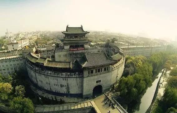
For anyone planning fieldwork or a research trip, the Han-Wei site offers the most direct physical evidence. The Sui-Tang site offers the best integration with modern urban geography. Wangcheng offers the least surface visibility.
When the Dynasty-to-Site Mapping Does Not Apply
There are limits to this framework. It works for the major imperial capitals. It does not work for every settlement in the Luoyang area.
Some periods have no clear capital site. The late Western Jin collapse, the Sixteen Kingdoms period, and the early Sui construction years are messy. Multiple small fortified settlements existed. A source from 350 CE may refer to a garrison town, not an imperial capital. The mapping table above does not cover those cases.
Religious and ritual sites also break the pattern. Baima Temple predates the Eastern Han capital by several decades, according to traditional accounts. The Longmen cave temples, south of the Sui-Tang city, served all the dynasties that held the area. They are not tied to one walled enclosure. A source mentioning Longmen tells you about patronage and belief, not about which capital site the court used.
Finally, the modern city of Luoyang is not a direct continuation of any single ancient site. It overlaps the Sui-Tang city most closely. But modern roads, railways, and industrial zones cut across all three sites. The dynasty-to-site mapping is a historical tool, not a modern land-use guide.
For researchers, planners, or educators working with the historical geography of lo yang china, the practical takeaway is simple. Identify the date first, then the river, then the gate or landmark. That sequence resolves most questions. If you need help locating specific excavation reports or site boundaries for a research project, ask for a reference list tailored to your period of interest.
